New App for Cyclists by NaviTime
 New app by NaviTime for cyclists to help them plot the best, safest bike routes – $4 for iPhone and free for Android: http://bit.ly/M5nIHE
NAVITIME Japan Co., Ltd. (President and CEO: Keisuke Onishi, Head Office: Minato-ku, Tokyo), at “NAVITIME bike” bicycle navigation application, or check on the cycling road map, to view photos and detailed information We will begin offering from Friday, July 13, 2012, can be a “special cycling” ※ .
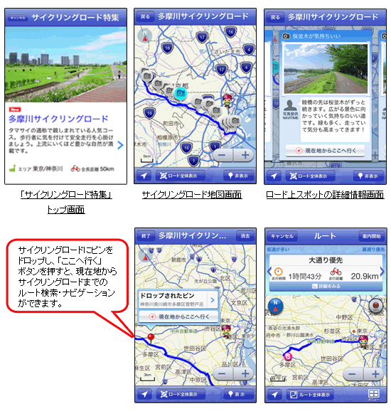
In this special issue, because it displays a line load cycling on the map, or check the positional relationship between the current location of navigation is also possible to load cycling. In addition, to expand the map, where it also points to cross the river, such as hesitation, you can see the exact route.
In addition, as information on the load, or “landscape”, When you touch the camera icon on the bike path was drawn on the map, such as “toilet” “spot stop”, the point would be helpful during the cycling, I will introduce with pictures and comments.
This time, featuring the “Tama River cycling” as the first. We are planning to add support cycling in the future.
NAVITIME Japan, in order to meet the diverse needs of our customers, to improve the accuracy of the data and feature-rich, will strive to further improve services.
※ apps for the iPhone, but currently is not supported, July 13, will be published soon.
An overview.
Cycling Road Overview
Area to pass through (prefecture)
All long-distance
Photos and comments such as “state of the Road”, “toilet”, “convenience store”, “views” in “spot stop” on the Cycling Road
This time, featuring the “Tama River cycling” as the first. We are planning to add support at any time cycling in the future.
Two screen image.

3 start date provided.
July 13, 2012 (Fri.)
Service charge for 4. (Tax included)
iPhone: 350 yen (Kaikiri)
(Also for au smart path) Free: Android

